作者:Chunyan Cheng,Fei Zhang,Xingyou Li,Mou Leong Tan, Pankaj Kumar, Brian Alan Johnson, Jingchao Shi,Qi Zhao, Changjiang Liu
摘要:Study region: Bosten Lake (Xinjiang, China). Study focus: This paper mainly focuses on quantifying changes in water storage of Bosten Lake using multi-mission satellite data. From Landsat images, we firstly extracted the lake area changes between 2003 and 2022 with the help of the modified normalized difference water index (MNDWI); Secondly, we used ICESat-1, CryoSat-2, and ICESat-2 altimetry data to draw the information of the water surface changes of the lake; Finally, the factors influencing the changes of the water volume of Bosten Lake were analyzed using meteorological and human activity data. New hydrological insights for the region: The findings indicate that the area of Bosten Lake has reduced from 1037.9 km2 to 1015.77 km2 , the water level has fallen by 0.58 m, and the volume of water has lost by 1.07 km3 between 2003 and 2022. During this period, the temperature and precipitation changes did not significantly correlate with the lake changes. In fact, lake change has obvious relationship with ecological water transfer and agricultural activities in the area. This paper is meaning in strengthening the understanding of the variation of freshwater lakes in arid areas under the background of global warming and its role in the regional water system. It also correctly assessed the impact of climate change and human activities on lakes as well as provide technical support for the sustainable development of ecological environment.
点击链接阅读全文~
22-2023-Chen-1-s2.0-S2214581823001830-main

创建: Aug 08, 2023 | 13:03
作者:Muhadaisi Ariken,Fei Zhang,Ngai weng Chan,Hsiang-te Kung
发表年份:2021年
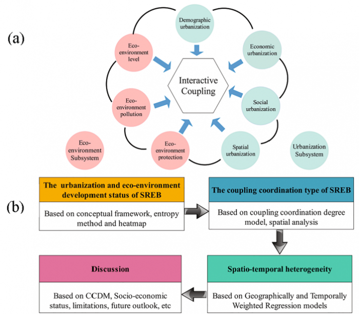
摘要:Rapid urbanization in China in recent decades has given rise to increasingly serious ecological and environmental problems. Specifically, the provinces along the Silk Road Economic Belt (SREB) in China have experienced rapid urbanization, and need to take pro-active action in balancing urbanization development with eco-environment conservation. This paper aims to develop comprehensive urbanization and eco-environment (UAEE) evaluation models to explore UAEE development of SREB in China from 2004 to 2018. In terms of methodology, these evaluation models are subsequently combined with CCDM (Coupling coordination degree model) and GTWR (Geographically and Temporally Weighted Regression) models to measure and analyze coupling degree and spatio-temporal heterogeneity of UAEE. The results show that: Firstly, from 2004 to 2018 in all regions of the SREB, the urbanization showed a gradual upward trend. Among them, comprehensive urbanization index (CUI) of Guangxi increased by 3.067%. Secondly, the comprehensive eco-environment index (CEI) of Chongqing, Sichuan, Guangxi, Shaanxi and Gansu has improved; while the eco-environment quality of Yunnan, Qinghai, Ningxia and Xinjiang has deteriorated during this period, with the rate of decrease in Xinjiang reaching a significant 2%; Thirdly, in 2018, Chongqing, Sichuan, Guangxi, Shaanxi and Gansu are in a state of high coordination level with the eco-environment under the rapid urbanization process, while Yunnan, Qinghai, Ningxia and Xinjiang are at a moderate coordination level. Since 2011, these areas are in a state of lagging development of the eco-environment. Finally, the interactive relationship between UAEE tends to converge. There is heterogeneity in time and space among SREB regions. The negative interaction effect of UAEE is mainly focused on the northwest regions. In conclusion, this research will provide a basis of scientific evaluation for the coordinated degree of UAEE, promote regional urbanization vis-` a-vis the improvement in environmental policy making.
点击链接阅读全文~
j.ecolind.2020.107014
创建: Aug 08, 2023 | 12:57
作者:Muhadaisi Ariken,Fei Zhang,Kang Liu, Chuangling Fang,Hsiang-Te Kung
发表年份:2020年
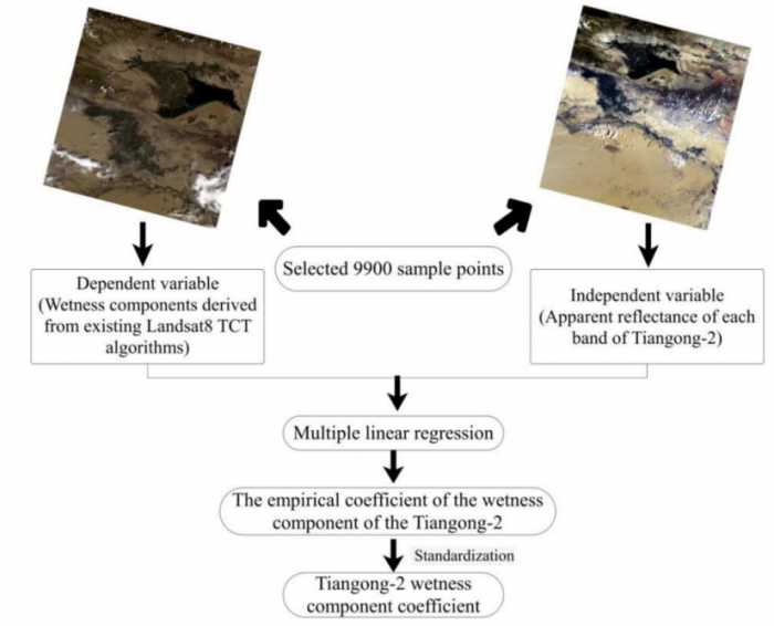
摘要:While multi-source remote sensing technology has the advantage of accurate and objective quantification, an understanding of the coupling and coordination between regional urbanization and ecological environment is the basis for achieving regional sustainable development. This paper builds the Remote Sensing Ecological Index (RSEI) based on Landsat data and Tiangong-2 WIS, using multi-source remote sensing data to comprehensively evaluate the coupling and coordination relationship between urbanization and ecological environment with a coupling coordination degree model in China's typical arid area of Yanqin Basin during 2000–2018. The results show the RSEI index has a certain rationality and superiority in assessing the ecological environment. In 2000–2018, the ecological environment of the Yanqi Basin was optimized, the RSEI index increased by 23.06%, and the overall ecological environment was at a good level (0.6–0.8). At the same time, the urbanization level of each town had been significantly improved in Yanqi Basin. Through the urban center of gravity transfer model, it was found that direction of urban development shifted to the southwest direction by 7.49 km, which is basically consistent with the position of poor ecological environment. Finally the current urbanization and ecological environment coupling relationship in urban areas of Yanqi Basin was found to exhibit a sluggish rate of urbanization with a moderate imbalance between urbanization with ecological environment. Therefore, when making decisions for planning the regional economic development, the concept of ecological relationships should be integrated to effectively protect and achieve a healthy and sustainable development of the region.
点击链接阅读全文~
j.ecolind.2020.106331
创建: Aug 08, 2023 | 12:54
作者:Yunfei Cai, Fei Zhang,Pan Duan,Chi Yung Jim, Ngai Weng Chan,Jingchao Shi, Changjiang Liu,Jianguo Wang, Jupar Bahtebay,Xu Ma
发表年份:2022年
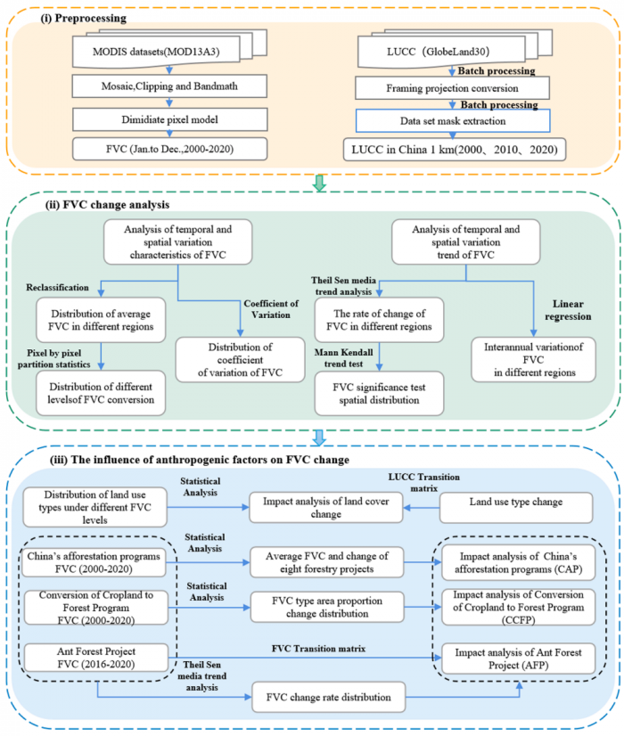
摘要:Vegetation-coverage research shows China’s significant 25% contribution to global greening. Vegetation is the link between water, soil and atmosphere, making it an important indicator of changes in anthropogenic factors. Anthropogenic attribution analysis of vegetation change helps us to identify and estimate the relationship between vegetation change and major ecological projects, and their corresponding relationship may be the antecedents and consequences of vegetation dynamics. This study assessed the increment and change rate of fractional vegetation cover (FVC) in 2000–2020 in China. The influences of land types and major ecological projects were systematically compared to assess the vegetation-human nexus. China has experienced progressive greening in the study period with regional variations in patterns and causes. The FVC changes and spatiotemporal variations were induced by notable human activities such as land-use conversion, China’s afforestation programs (CAP), Ant Forest Project (AFP), and Conversion of Cropland to Forest Program (CCFP). The North region recorded the highest change rate. The area changes in cropland, grassland, and forest were the main FVC drivers. The average FVC change rate of CAP changed very high in 21 years. The AFP exerted significant impacts on FVC changes. The CCFP effectively promoted FVC improvements from the low, medium and high grades to the very high coverage grade. These comparative trends illustrated the intricate relationships between anthropogenic factors and greening. The findings could enhance the prediction and evaluation of vegetation-cover dynamics under anthropogenic changes and the implementation and management of afforestation programs.
点击链接阅读全文~
1-s2.0-S0341816222005161-main
创建: Aug 08, 2023 | 12:51