


城市生态遥感分析
城市化是人类社会发展的必然趋势,据世界银行统计,2020年全球人口为77.53亿,城市人口为43.52亿,到2050年,城市人口的比例将达到68%。伴随着城市化进程和人类活动强度的加剧,城市生态系统正面临着日益严峻的挑战。及时地开展城市生态的监测并发现所存在的问题,有利于维护城市生态的稳定性并助力可持续发展目标(SDGs)的实现。为了积极响应SDGs目标,城市生态与人居环境团队借助多源遥感数据,收集城市生态系统的专题信息,实现对城市生态过程和环境机制的综合表征,包括:联合卫星与地表传感网的多维城市热环境感知,为改善城市热岛效应提供理论支持;基于城市水文传感大数据,结合城市地表景观格局,对城市地表径流与内涝风险进行智能分析和决策;基于昼夜遥感协同的人类足迹与区域生境的动态追踪,有助于揭示人类活动对生境状况的作用。已发表相关领域学术论文20余篇,授权发明专利1项,省部级以上项目资助20余项,获得广东省科技进步奖一等奖、华夏建设科学技术奖一等奖等奖项。
标志性成果:
城市热环境与景观分析:
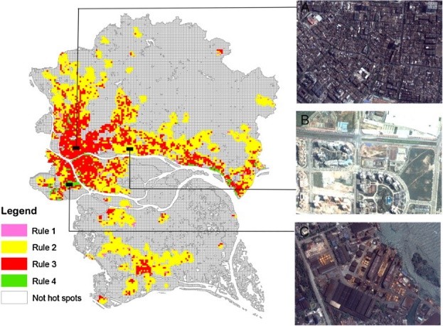
郭冠华副教授在JCR Q1期刊《Landscape and Urban Planning》上发表题为“Impacts of urban biophysical composition on land surface temperature in urban heat island clusters”的文章,通过引入了一种创新的集成方法,将面向对象的图像分割与空间自相关的局部指标 (LISA) 相结合,从LST 图像中提取UHI簇,所建立回归树模型能够有效地检测LST与生物物理成分之间的非线性关系。该研究结果有助于更全面的理解城市景观配置与热环境的关系,可为缓解城市热岛效应提供支持。
城市内涝模拟评估:
张棋斐博士生在JCR Q1期刊《Science of The Total Environment》上发表题为“Explicit the urban waterlogging spatial variation and its driving factors: The stepwise cluster analysis model and hierarchical partitioning analysis approach”的文章,提出了一种在通用框架内结合逐步聚类分析模型(SCAM)和层次划分分析(HPA)的新方法,并通过逻辑回归、人工神经网络和支持向量机验证其适用性。该研究本有望为SCAM和HPA在城市内涝模拟与评估中的进一步应用提供有益信息,为内涝风险防范带来启示。
地表光污染追踪:
郑子豪博士在JCR Q1期刊《Global Environmental Change》上发表题为“Africa's protected areas are brightening at night: A long-term light pollution monitor based on nighttime light imagery”的文章,使用统一的多传感器NTL数据对非洲保护区的光污染进行了长期(1992-2018)的监测和评估,并探讨了人类活动强度对保护区内光污染的最大作用距离。该研究为理解保护区内的光污染模式提供了新的方法,对未来的保护区规划具有重要参考价值。
主要成果列表:
- Guo, G., Wu, Z., Xiao, R., Chen, Y., Liu, X., & Zhang, X. (2015). Impacts of urban biophysical composition on land surface temperature in urban heat island clusters. Landscape and Urban Planning, 2015,135:1-10.
- Guo, G., Wu, Z., & Chen, Y. Evaluation of spatially heterogeneous driving forces of the urban heat environment based on a regression tree model.Sustainable Cities and Society, 2020,54.
- Zhang, Q., Wu, Z., Guo, G., Zhang, H., & Tarolli, P.. Explicit the urban waterlogging spatial variation and its driving factors: The stepwise cluster analysis model and hierarchical partitioning analysis approach. Science of The Total Environment, 2021, 763:143041.
- Zhang, Q., Wu, Z., & Tarolli, P.. Investigating the Role of Green Infrastructure on Urban WaterLogging: Evidence from Metropolitan Coastal Cities. Remote Sensing, 2020,13(12):2341.
- Zheng, Z., Wu, Z., Chen, Y., Guo, G., Cao, Z., Yang, Z., & Marinello, F.. Africa's protected areas are brightening at night: A long-term light pollution monitor based on nighttime light imagery. Global Environmental Change, 2021,69:102318.
- Zheng, Z., Wu, Z., Chen, Y., Guo, C., & Marinello, F. Instability of remote sensing based ecological index (RSEI) and its improvement for time series analysis. Science of The Total Environment, 2022,814:152595.
- 一种城市热岛范围的提取方法及装置(ZL201810056935.X),发明专利
